|
AEROPHOTOGRAPHIC
MAPS
Size: 48cm x 60cm
Price: U$15.-
BUY IT WITH

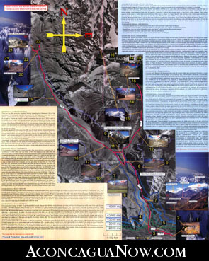
Printed
in English and Spanish. This guide will show you the path to follow (which
you can see in an excellent aerophotography image.) from the last little
town called “Puente del Inca” to the base camp. Two walking
journeys with tips, coments, altitude lines, and pictures that will help
you get to the base camp “Plaza de Mulas” without any inconvenience.
|
|
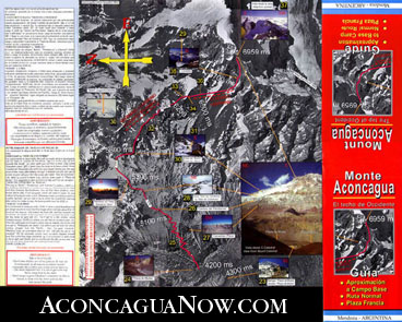
This
map will also indicate you how to get to the south wall and to the base
camp “Plaza Francia”. The other side of the guide shows the
ascension from the base camp “Plaza de Mulas” to the summit
on the regular route with tips, timing, altitude, and pictures which will
be a great help.
|
|
TOPOGRAPHIC
MAPS
PRICE:
U$15.-
BUY
IT WITH
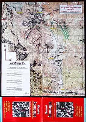
Printed
in English and Spanish. Topographic
chart of Aconcagua park´s area with high lines and way points. On
one side of the chart you will find the topographic area which it will take
you close the ascending regular route by the Horcones cliff (quebrada) until
the base camp "Plaza de Mulas". |
|
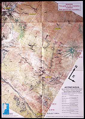
On
the other side of the chart you will find the topographic area close to
the "Glaciar de los Polacos"(polish glaciar) by the "Punta
de Vaca"´s cliff (cow¨s point) until the base camp "Plaza
Argentina".
|