FIRST
ARCHAEASTRONOMIC
INCA PLACE DISCOVERY
IN MOUNT ACONCAGUA
ABASTRAC
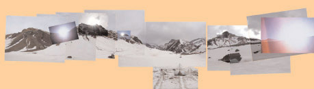
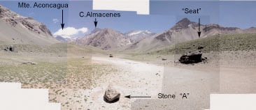
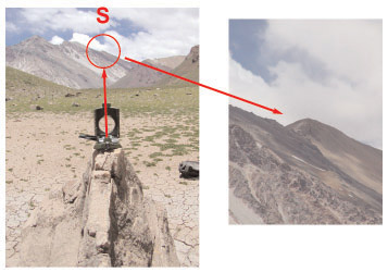
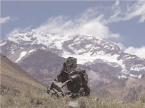
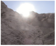
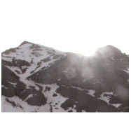
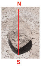
At the entrance to the Quebrada de Horcones ("Gulch of Horcones")
forced step to the Mount Aconcagua we found a Inca archaeastronomic
place. There is a main stone we believe that it is an Intiwatana
(quechua voice that means the "stone that ties
the sun" or "mooring of the sun.". The Intiwatana
of Machu Pichu, in Perú is the most famouse in the world)
next to another series of associated rocks.
INTIWATANA
Site "Ibarra Grasso"
(Argentine investigator who passed away in year
2000,
who dedicated all his life to the studies of the origen of the american
men)
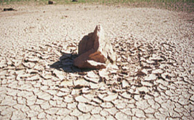
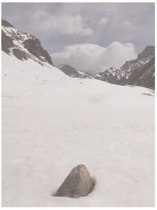
The stone It is a rhomboidal of approximately 1 meter long, 70 cms.
wide, and 80 cms. height in its highest side. While I watch it (in
back I have the river Cuevas) we can see its location clearly regarding
the Aconcagua.
Looking at it turned back to the Aconcagua several rustic but clearly
defined planes can be seen:
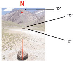
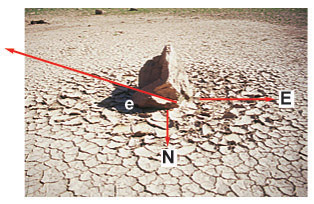
1 - Cardinal points
From the position where the intiwatana is we can observe several
elements or characteristic of the land that coincide with the cardinal
points.
North
Previously observe we can see that there is one clear rhomboidal
face. The magnetic North goes exactly by what it could be the major
diagonal, so, if we project that diagonal in an imaginary way we
can see how that line crosses about 120 steps with a great stone
"B" and about 30 steps shorter with another "C",
continuing the projection we can see as it intersect the summit
that is in the entrance of the Hill "Quebrada del Durazno"
crossing almost point "D".
South
The projection toward the infinite of one imaginary line towards
the South points out exactly toward a small summit that is on the
bard on the other side of the river Cuevas.
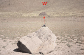
West
The West is marked by a great rock which is about 50 meters away.
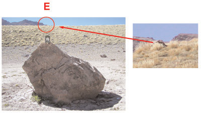
East
And the East is a result
of an intersection of the border of the land where the intiwatana
is and the mountains that are on the other side of the river Horcones.
Proyecting one imaginary line in the high part of the land this
line intersect a stone that is in that way and direction.
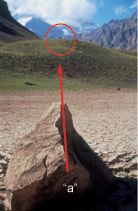
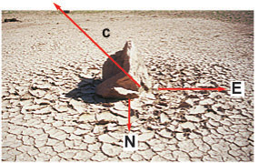
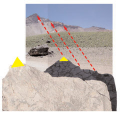
2 - Edge "A" - "The
Guardian"
If we look at the edge that we denominate "a" in a Northwest
direction and projecting one imaginary line toward the infinite
we can see that about 200 meters there is a rock (which we denominate
"the guardian") that stands out clear and solitary on
the land, it has an anthropomorphic shape, a great volume and a
small one on top that remainds you of a thorax and a head next to
an extended arm with the hand on the chest.
"The Guardian"
This last comment about the arm over the
chest Prof. Ibarra Grasso told us belongs to a kind of a chamanic
greeting. According to this we can say that the form of the arm
stands out thanks to a series of planes that point up what allows
them to be always britten, following the projection this one intersect
the Aconcagua and elevating the vertical of this point coincides
almost exactly with the summit of the same one.
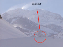
View of "The Guardian"
from the intiwatana
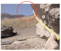
Edge "b"
By the edge "b" in a NorthEast direction and projecting
a new line we can see that this one intersect a rock of a medium
size about 50 meters in the East hill:
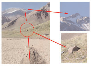
Continuing the projection toward the horizon this line cuts the
land just in a summit (which name we ignore). It will be important
to go by that place to see what we can observe...
3 - Season of the year
We where there during the different equinoxes and solstices what
allowed us to make different observations and mensurations.
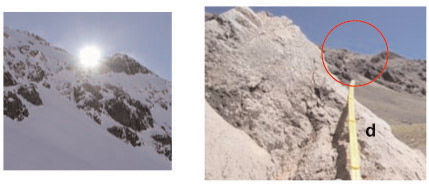
Solstice in winter
We were there in June 21 2003. Our interest was to try to see some
outstanding aspect in the places where the sun raises and sets the
possible aspects of the lights/ shadows. But the approximate place
where the intiwatana would be was covered with approximately 1 meter
of snow. However we realized that from the moment that the sun raises
(10:34 am) until to time that it reaches its highest point or culmination
(approx.1:40 pm) 3 hours passed. This point is exactly on the projection
of the point "D" obviously marking the North. Between
this point and the point of the sun set again almost 3 hours more
went by (4:36 pm), that is to say that the time that passed since
the sun raised at its highest point is the same time as when the
sun sets. On the other hand comparing the picture of the place where
the sun raises with pictures taken later on (since at that moment
intiwatana was under the snow) we could confirm that the edge "c"
points out exactly the place where the sun raises for this equinox.
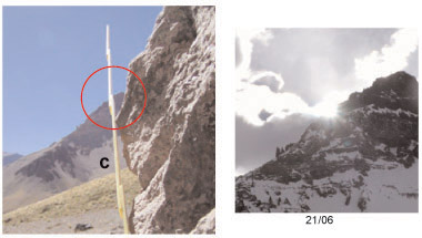
and the edge "d"
shows exactly the place where the sun sets
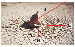
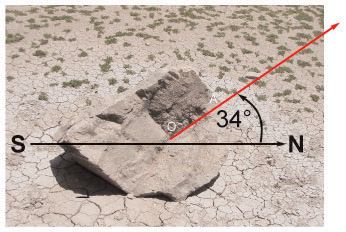
The
point of maximum height or culmination of the sun for this date
(that is to say for the shortest day of the year) and for this latitude
(32° 50´Sur) it is of approximately 34°.
Because if we observe the face of the intiwatana that points toward
the East we can observe a series of features or lines clearly marked.
The angle formed by OA regarding the axis North - South is approximately
of 34°.
View of the intiwatana from East to West
Equinoxes (Spring - Autumn)
Observing by the projection of the edge "e" in the infinite
we could see that it points out the site where the sun raises for
the Spring and Autumn equinoxes.
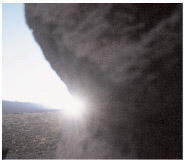
Sun raising seen from the edge "e" March 21.
Sun raising September 21.
The difference of the contour of the land
corresponds to the difference of height between one shot and the
other.
Observing on the edge "f we could confirm that it points out
the place where the sun sets.
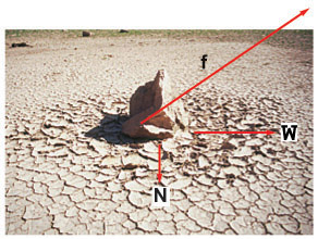
Setting of the sun from the edge "f" March 21.
Setting of the sun September 21
It is interesting to highlight that when we were there for the Spring
equinox (9/21/03) the intiwatana was almost totally under the snows
as it was for the solstice of Winter what made it impossible to
us to make these observations that we were able to discover and
to carry out in the Autumn equinox (3/21/04).
We can only see the superior side of the intiwatana September 21.
Same as for the Solstice of Winter in the side that is towards the
East we could see one line clearly marked BO that regarding the
axis North - South formed an angle of approximately 56°
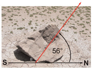
This is the exact peak of the Sun for the Autumn and Spring Equinoxes
Solstice of Summer
There is a feature that marks the peak for the Sun for December
21 that is to say the maximun height for the Sun of 80° in the
longest day of the year.
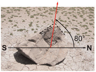
That height point corresponds to the angle formed by the imaginary
line OC related to the axis North-South. The point C is formed by
the intersection of the lines AC and DC (although the rock is not
there). But if it was there the vertex C (the meassing part of the
stone) we think that some similarity may exist between the shadow
from this projected stone from West to East with the cut of the
mountains that are located toward the East:
Projection of the shadow December 21
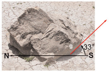
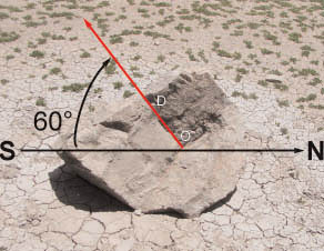
Celestial South pole
We could see as the angle formed by the edge "g" regarding
the horizontal of the land it is of approximately 33° that as
we already saw it is almost exactly the latitude in this place therefore
it is from here where the height correspond to the celestial south
pole.
The Aconcagua in the intiwatana
Remembering Prof. Ibarra
Grasso that so many times have spoken to us about "to think
different" looking at a picture that we had taken of the intiwatana
in a zenithal way we think we saw the cutting of the summit of the
Aconcagua (commonly known as "El Filo del Guanaco") that
we have from this perspective.
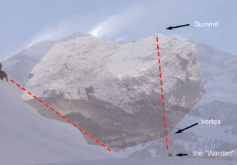
We put one picture over the other and then we could see as one of
the profiles of the stone travels the profile of the Aconcagua lacking
exactly a vertex to the left (corresponding to the South summit)
we don't know if this lacking part is intentional or not. We can
also see as the left lower side coincides almost with the cutting
of the land and like an imaginary line unites the summit with a
vertex of the stone to the anthropomorphic figure which we have
denominated "The Guardian"
The South Crox constellation in the intiwatana
Putting one picture of the
Cruz of the South over the rhomboidal face of the intiwatana (face
oriented toward the South) we found out that the proportions between
the stone and the four main stars of this constellation are almost
exact:
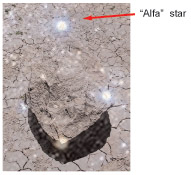
On the other hand the angle
formed by an imaginary OD line regarding the South-North axis is
of approximately 60° which is the height point of the base of
the South Croix (Alpha star of that constellation) in its movement
around the celestial axis:
_____________________________________________________________________________
[email protected]
May 2002 - Julio 2003 - September 2003 - December 2003 - March 2004